
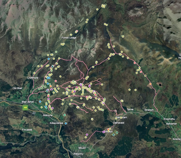
Between Glen Tilt and Glen Fernate, with the smaller glens between of Fender and Girnaig is an area that encompassed and maintained over many centuries an agrarian population. The extant evidence including hut circles to small settlements/farmsteads with a range of shieling sites comprising of numerous shieling huts (or bothies) in the upper regions, also to be found scattered throughout the area are many lone huts, perhaps these more accurately as they are not immediately associated with a particular shieling area should be called bothies.
The area of approximately 220 km2 was served by several main tracks that aided the transportation of livestock and general movement to the shielings and areas of settlement. Many of the tracks have disappeared through lack of use and demise of the population but several of the main routes can still be traced if at times vaguely. Several of these tracks have been upgraded and are now part of the estate vehicle (inc. atv’s) access. Observation of the tracks will show in certain areas considerable braiding or variation from any singular route.
The Google map (LINK) (Google Earth LINK) was created partly knowing the area and visiting its various shielings but also through discovering the work of John Kerr who wrote ‘The Old Roads to Strathardle’ and ‘Life in the Atholl Glens’. amongst other books about the area. Kerr had walked over and recorded details of the shielings and settlements, especially noting their names through research of various sources but specifically the estate archives of the Duke of Atholl and Robertsons of Lude. These two families for centuries being the principal landowners of the map area.
Kerr gives statistical context, specifies locations plus names to the principal shieling sites and importantly names to many of the people and also the rent they paid, as well as indicating the routes travelled. These routes took people and livestock not only from and to their various farms etc. down in the lower strath by the River Garry and Strathardle but also to the principal markets at Moulin and Kirkmichael, amongst others over the years.
The routes were also used by drovers bringing cattle down from the north of Scotland. They would also have had overnight stances in the area for the livestock.
The various sites indicated came and went over a considerable period. Ending with just the one main area farm that we see today at Monzie, smaller farms are found in Glen Tilt, Fender and Fernate. Changes in agricultural practice, land ownership whims, the industrial revolution, wars (Napoleonic), improved social standing amongst other factors would see the eventual demise of people living and working in the area. There was it seems initially relatively minimal impact of people being cleared from the land in this area, this did happen latterly but generally it was gradual compared with many areas of land cleared for sheep elsewhere in Scotland.
The Google map is fairly self explanatory with what the dots indicate. The main thing is that the yellowy green dots include both shieling related and various settlements, lone shieling type huts are just that, outlying huts that served a now lost purpose but are an important element in the landscape. It was just easier to lump those shieling settlement sites all together for the purpose of the project.
Hut circles are purple and fanks and roundels are red, blue dots are miscellaneous historical sites.
Very few of the sites are recorded on the main Historic Environment Scotland main database Canmore (Note: Canmore no longer exists with HES transforming it into a single database called Trove) (https://pastmap.org.uk/map). More information can be found on the Perth and Kinross Heritage Trust interactive map (https://www.pkht.org.uk/pkher/) with links to HES for more details. The PKHT interactive map does cover several patches of deserted settlements that are now scheduled. No database features the numerous shielings or lone shieling type huts, bothies or enclosures etc..
Of great help was Stobies map of 1783 and as you can observe around Shinagag there is some confusion as to what can be identified on the aerial imagery. (National Library of Scotland Stobie Link) Also the map by Thomson, John, 1777- ca. 1840; based on Stobies map (National Library of Scotland, Thomson Link) this in particular like Stobies shows many named settlements are hard to locate and many of the 'Shieling huts' might well be some that are named by Thomson.
The map was created using Google my maps, but Bing aerial was also used extensively along with Apple map aerial. Both Bing and Google Earth allow for changing angles and moving around to show sites in relief, Google Earth in particular helped to determine if a site was as it seemed as it gives much more ability to zoom in and out, angle and rotate that helps viewing a possible site and its structural relief. It is important to refer and check with the various aerial sources as they vary in quality and get updated reasonably regularly. Update: Apple maps (same as: satellites.pro/uk) now has the best aerial/satellite imagery and if you click on 2D you can zoom in even more as well as tilt etc..
As many sites as possible have been noted but there will be several undoubtably missed or questionable as, hence the occasional '??' after names. There will of course be false optimistic observations and the map is just a start that can and will be updated and corrected. Usually sites are double checked by doing a walkover for confirmation but for the purposes of this project that hasn’t always been possible. Names to might need correcting but as spelling frequently changed across different maps… The gaelic meanings also might be open to variation.
This is the Link to Google Earth that should work showing the name of sites. I can send the latest base kmz file if anyone wishes.
Let me know of any observations or corrections.
